Words by Hannah Palmer
Photos by Claudia Maturell
A most unusual creek
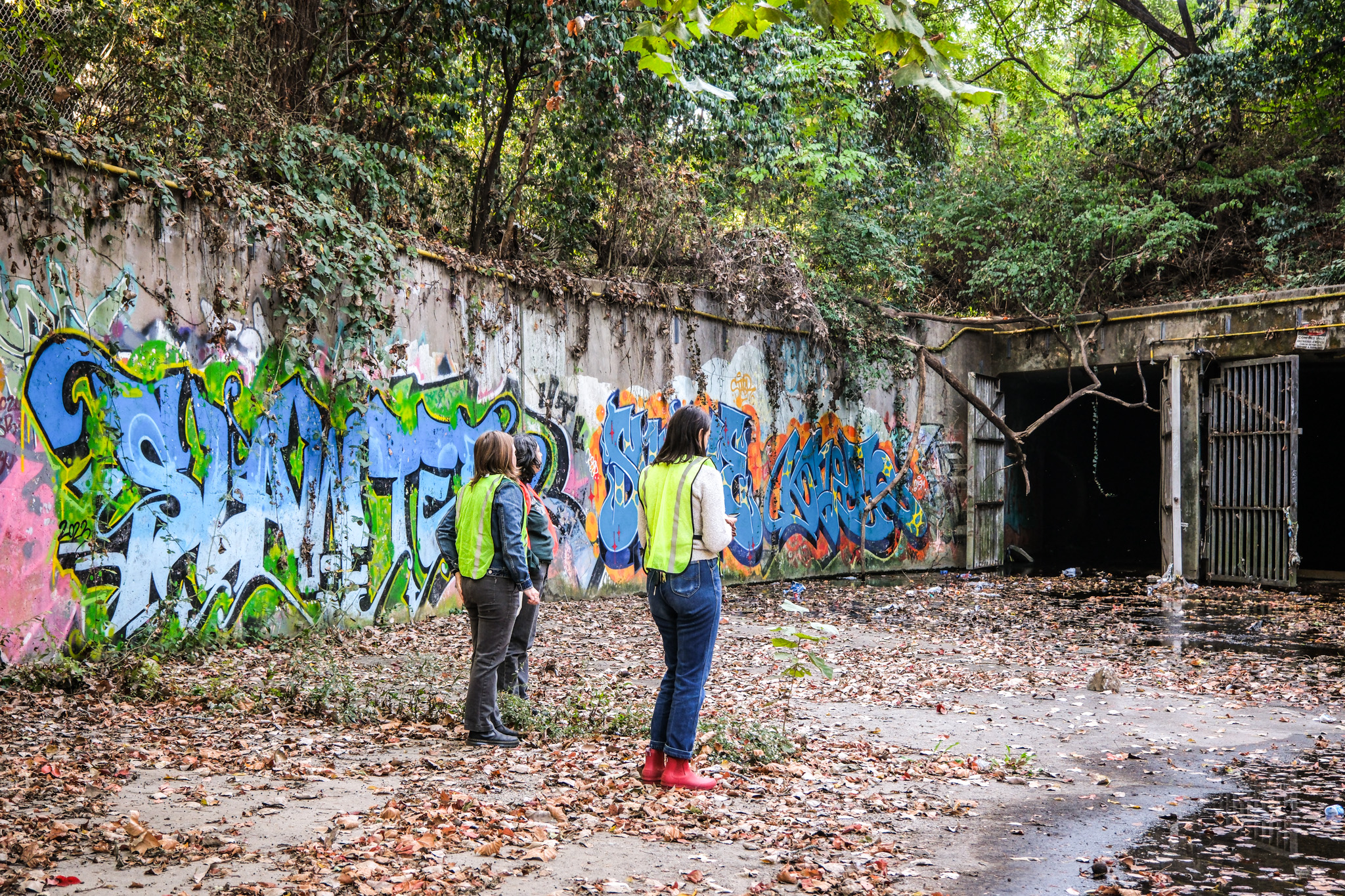
A strange concrete channel lies in the shadow of I-75 in northwest Atlanta. Fenced and nameless, it snakes through a ravine between the interstate and a dense patchwork of condos.
At the south end of this channel is a graffiti-covered culvert under the highway, marked as a CSO outfall, or combined sewer overflow. But in the half mile that follows, something phenomenal happens: This dark trickle of water transforms into a jewel in the Beltline’s emerald necklace, Tanyard Creek Park.
This concrete channel isn’t natural, but exploring it on a sunny Saturday morning in October feels like a nature walk. The steep concrete banks are scattered with acorns and black walnut pods. Blue mistflower and asters sprout in the cracks. Through the branches, northbound traffic speeds by in a blur. This liminal space—between the Brookwood Split and Collier Hills—is Tanyard Creek, bursting into life after a long journey underground, where, for nearly three miles, it’s strangled. For more than 60 percent of its length, the creek is a concrete drainage system shuttling stormwater and sewage away from Downtown, Atlantic Station, Georgia Tech, and West Midtown. Tanyard—buried in part by the Downtown Connector—strikes me as the most violently engineered creek in Atlanta.


I visited this spot, curious to see how our normally hidden stormwater infrastructure becomes visible. As Tanyard emerges from its concrete channel, it enters Buckhead, an area with a median income more than double the rest of Atlanta. The transformation that follows—from open sewer to urban oasis—shows what’s possible when a distressed creek is restored to a healthy condition. It’s no coincidence that this transformation occurs in a wealthy, majority white neighborhood.
“A creek can’t be racist, but infrastructure can.”
—Hannah Palmer
In more vulnerable communities across Atlanta, contaminated creeks remain a nuisance and a threat. They show how infrastructure can weave inequality into the fabric of a city. Even as our values—and political leaders—change, inequality persists because it is built into the foundations of our city.
The way Atlanta engineered its creeks out of existence is a sin that continues to cause problems today, from nuisance flooding that disrupts traffic to severe floods that destroy property and disrupt lives.
Under the pavement
Atlanta’s creeks represent some of our oldest municipal infrastructure. Somewhere between the end of Reconstruction, circa 1877, and the 1906 Atlanta Race Massacre, Atlanta built its first sewers by lining creek beds with rocks. Gravity and perennial springs provided free infrastructure for the people and businesses uphill and upstream. The creeks could only wash away so much filth, though, before they had to be fully piped to manage the stench and prevent disease.
“Before the Clean Water Act added stormwater in the early 1990s, stormwater was considered part of a road or neighborhood, not a separate system that would be mapped and managed.”
—Katherine Atteberry, Stormwater Planning Manager for the Atlanta Regional Commission
Those new pipes carried our waste—and our values. As waste accumulated throughout the city flowed downstream, Black communities in low-lying neighborhoods with names like Buttermilk Bottom, Beaver Slide, and Junglefoot contended with odor, contamination, and flooding.
You can see Tanyard’s course under the pavement with the U.S. Geological Survey StreamStats web tool, its blue lines a kind of x-ray of the city. The creek starts Downtown near the Tabernacle, then flows north, fed by the many springs under Spring Street. It continues past present-day Centennial Olympic Park, where its namesake (and original polluter) once stood: the Atlanta Steam Tannery, which manufactured leather goods for Confederate soldiers. By 1928, an atlas labeled the stream “trunk sewer,” fully converted from a creek to a primary pipeline for the city’s waste.


There are similar concrete channels around town, scarring many of our urban creeks. A channel cuts through John A. White Golf Course, containing a sad segment of Utoy Creek. The first daylit stretch—meaning where it emerges from a pipe—of Intrenchment Creek dribbles through a concrete ditch east of Boulevard, smelling like bleach. When I was a kid, a ditch containing Clear Creek bisected the meadow in Piedmont Park.
A creek is neutral. A drainage system, however, is manmade, designed to serve the interests of the power structures that fund and maintain it. Infrastructure is made up of decisions and values, a product of culture with historical and political context. A creek can’t be racist, but infrastructure can.
Drainage Justice
As Atlanta grew, downstream neighborhoods became what environmental justice advocates call a “sacrifice zone” for our mega projects built on higher ground. In the Proctor Creek watershed, the GWCC–Mercedes-Benz Stadium district contributes to flooding in Westside communities. In Southeast Atlanta, runoff from the I-20/Connector tangle and Atlanta-Fulton County Stadium/Center Parc Stadium rushes into Peoplestown. South of Hartsfield-Jackson Atlanta International Airport, the Flint River Headwaters surge into northwest Clayton County neighborhoods.
This isn’t just an Atlanta problem. In Houston, activists coined the term “drainage justice” to describe the uneven impact of flooding on low-income, often Black and immigrant, communities. In most American cities, large and small, you see the dichotomy of the Heights and the Bottoms: wealth upstream, flooding and pollution downstream.


In 2013, the City of Atlanta instituted an ambitious ordinance that requires developers to capture and slow the first inch of stormwater on-site. This has helped encourage green infrastructure, but only for new construction and redevelopment. Addressing historic flooding issues requires focused effort and sustained funding; still, in many parts of Atlanta, stormwater infrastructure remains an afterthought: out of sight, out of mind.
According to Katherine Atteberry, Stormwater Planning Manager for the Atlanta Regional Commission, “Before the Clean Water Act added stormwater in the early 1990s, stormwater was considered part of a road or neighborhood, not a separate system that would be mapped and managed.”
This explains why you don’t have to go far to find a blocked or crumbling storm drain. When it comes to our infrastructure—the network of pipes, detention ponds, culverts, storm drains, catch basins, and all the other manmade features that funnel water to wherever it’s supposed to go when it rains—huge gaps in our knowledge hamper our ability to address flooding.
“Until we manage stormwater like public infrastructure, it’s going to be hard to take pressure off neighborhoods.”
—Katherine Atteberry, Stormwater Planning Manager for the Atlanta Regional Commission
“I mean, generally we know where our roads are, but not our stormwater assets,” says Atteberry. And while other fundamental utilities are managed by certified operators with a dedicated budget for maintenance, “we ask homeowners to clear storm drains,” she adds. “We expect property owners to maintain detention ponds.”
When we pay a monthly bill for drinking water, sewer, electricity, or internet service, part of that money goes towards maintaining the complex and invisible system that delivers those goods to our homes. When it works, we don’t have to think about it. But with stormwater management in metro Atlanta, funding across municipalities is inconsistent, resulting in both confusion and inequality.
Because of climate change, the pressure on our aging infrastructure is only growing. For example, for decades, Westside neighborhoods downstream of the Gulch have been plagued by flooding. In response, the City acquired and demolished homes in Vine City to create the elaborate, 16-acre Cook Park, designed to hold 9 million gallons of rainfall and runoff during a storm.


This park performed well in September 2023, when an intense storm over downtown dumped three inches of rain in two hours. That still didn’t stop the Georgia Aquarium from flooding—or the Atlanta University Center, where dozens of people had to be rescued from their cars, dorms, and homes. This “cloudburst” phenomenon, part of the new lexicon of climate change, highlights the need for systemic upgrades.
“Until we manage stormwater like public infrastructure, it’s going to be hard to take pressure off neighborhoods,” says Atteberry. Until we rethink stormwater management in the Heights, there will always be a neighborhood in the Bottoms under pressure.
Systemic Change
Walking through the Tanyard Creek channel makes me think of the LA River, an iconic 51-mile concrete channel that the Army Corps of Engineers started constructing after deadly floods wreaked havoc in Los Angeles in the 1930s. Back then, the mega-project succeeded in protecting the city, but now it’s mostly known as an apocalyptic backdrop for action movie chase scenes. The LA River channel has become a stark symbol of the era of blunt force public works, when engineers-gone-wild plowed highways through neighborhoods, flooded valley towns for hydropower, and encased pesky rivers in concrete.
Today, it’s being rewilded and restored as an attractive greenway. The concrete riverbanks are lined with multi-use trails, community gathering spaces, and nature preserves. It’s not that the LA River doesn’t flood anymore; precipitation is just as haywire in California as it is in Georgia. The difference is that Los Angeles is remaking itself as a “sponge city,” investing in resilience through green infrastructure and citywide stormwater management.
“Nearby, once freed from this ditch, Tanyard Creek regains its name and its dignity as it fans out into a lush wetland.”
—Hannah Palmer
Here in Atlanta, at the end of a particularly dry October, it’s hard to imagine Tanyard Creek as a raging river. The channel only carries a shallow trickle of water, but the timeline for its construction tracks with California’s concrete channel. Both were built decades ago to tame unruly urban creeks and whisk the cities’ nastiest contents away.
Tanyard used to flood regularly with sewage. In 1997, it was at the heart of a lawsuit brought by the Upper Chattahoochee Riverkeeper Fund against the City of Atlanta for violating the federal Clean Water Act. The CSO facility by I-75, just half a mile upstream from where we’re walking, failed to treat the sewage that spilled into this creek during storms. The City finally addressed the problem by building an 8.5-mile diversion tunnel to direct polluted stormwater away from this neighborhood and to the R.M. Clayton Wastewater Treatment Plant.


Nearby, once freed from this ditch, Tanyard Creek regains its name and its dignity as it fans out into a lush wetland. A floating trash trap collects litter before the creek flows into a string of public parks and Bobby Jones Golf Course on its way to Peachtree Creek. This version of Tanyard proves what kind of restoration is possible with litigation, years of advocacy, and public investment.
We can’t solve flooding problems with lifeless concrete channels and massive diversion tunnels that serve one population at the expense of another. On the other hand, sexy stormwater parks have a risky impact when they replace a struggling neighborhood with an attractive green space. Traditional pipes and green infrastructure alike have to be paired with the continuous, costly, small-scale work of repair, as dispersed and democratic as the rain itself.
Editor: Heather Buckner
Factchecker: Ada Wood
Canopy Atlanta Reader: Genia Billingsley
Leave a Reply